Location
A small continent in the ocean

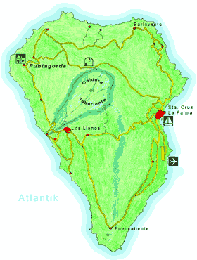
- Map of La Palma - enlarge
La Palma is the most northerly island in the Canary Islands archipelago and is situated in the Atlantic Ocean about 450 km off the North West African coast at 28° 40' northern latitude and 17° 52' western longitude.
On an area of 723 km2, the largest distance from north to south is just under 50 km and from west to east 28 km. The outline of the island resembles the shape of a heart, which is why it was given the name "Heart Island".
The surface of La Palma is dominated in the north by the enormous erosion crater, Caldera de Taburiente, surrounded by a mountain massif over 2400 m high. To the south, the mountain passes into a narrow ridge with more than 130 volcanic cones and craters.
La Palma is a steep island. Compared to its surface area, there are the largest differences in altitude on earth.
Climate
Island of eternal spring
La Palma has a subtropical temperate climate due to the Canarian Stream and the trade winds. With the exception of the mountain peaks, the temperature differences over the year are relatively small. Occasionally, the desert wind of the Sahara reaches the island and brings high summer temperatures for a short time.

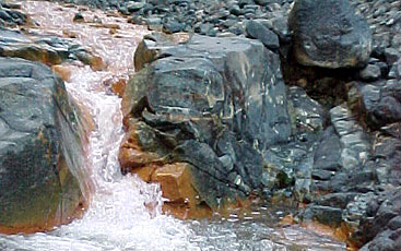
- Rio Almendro in the Caldera de Taburiente - the Stream Bed is Orange Coloured by Iron
La Palma is the only island in the Canary Islands where rivers and streams flow all-the-year. The constantly blowing north-eastern trade wind draws moisture over the sea, which is mainly reflected on the mountain slopes of the northeast and east due to the mountain massif running from north to south. Therefore, the climate in the west and south of the island is mostly sunnier and drier. Due to its exposed location and geographical structure, La Palma possesses the purest air of the northern hemisphere.
